Making a Guilder, a Pound, or a Buck
WHERE: Broadway and the eastern part of the Financial District in Lower Manhattan.
START: Fulton Transit Center: Fulton Street subway station (2, 3, 4, 5, A, C, J trains), fully accessible
FINISH: Bowling Green subway station (4, 5 trains), fully accessible
DISTANCE: 1.25 miles (2 kilometers)
Photographs by Michael Cairl except as noted. Map courtesy footpathmap.com.
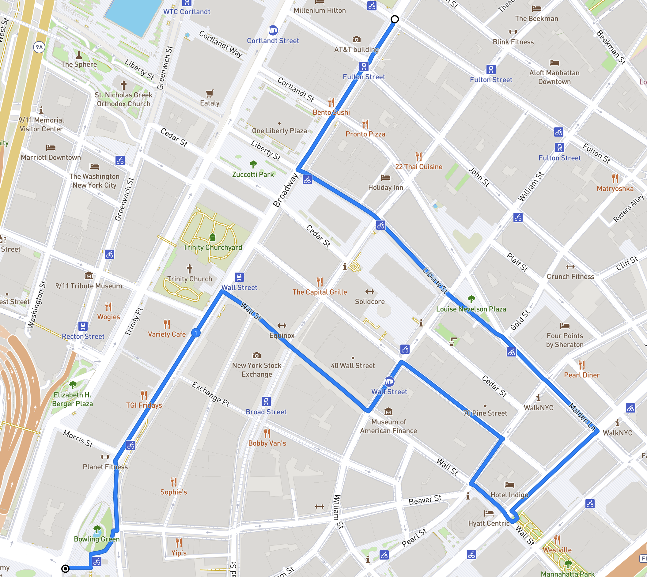
Route of this walk, going from top to bottom.
Some early arrivals in what is now New York City fled religious or political persecution - Deborah Moody in Brooklyn and Anne Hutchinson in the Bronx - and people still come to the city fleeing persecution. But New Amsterdam was founded by people seeking to make a few guilders, followed by the British wanting to make a few pounds, and after independence by people wanting to make a lot of dollars. This walk takes in some of that history. That seeking of riches came not only in the buying and selling of goods and financial instruments but in the buying and selling of human beings.
Starting at the Fulton Transit Center, turn left onto Broadway and walk south. This is the start of the “Canyon of Heroes” where dignitaries and celebrities have been treated to waste paper (ticker tape) being thrown out of upper story windows, an odd New York tradition, before arriving at City Hall to be presented with keys to the City. Stockbrokers used to get news of stock trades and prices on continuous strips of paper generated by “tickers.” Stock tickers are long out of use and ticker tape has to be specially ordered for these events. Every so often in the sidewalk you will see the commemoration of an individual or group that was treated to this sort of confetti, and the date on which it occurred.
Cross Liberty Street. Across Broadway is Zuccotti Park, where Occupy Wall Street staged a protest against economic inequality for 59 days in 2011. In front of you and to your left is 140 Broadway (1967) and Isamu Noguchi’s sculpture The Cube, whose tilt and red color play well against the smooth black skin of the building.
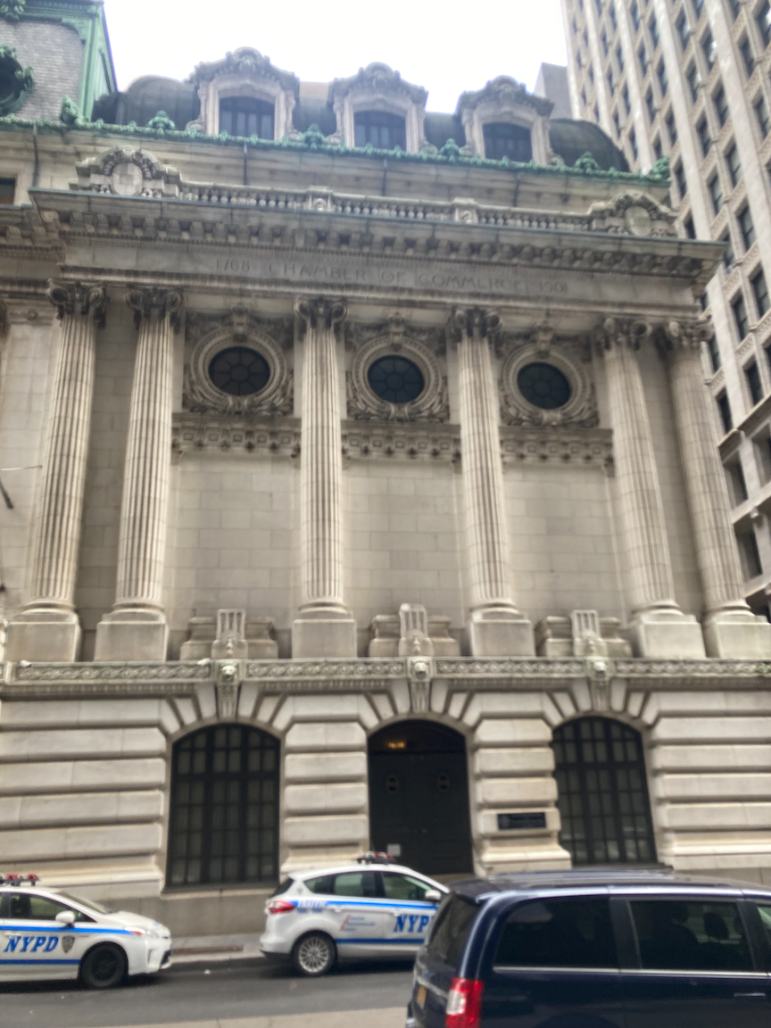
Turn left on Liberty Street. Across the street, near Nassau Street, is the former New York Chamber of Commerce (1902). The Chamber of Commerce moved to a somewhat less opulent location in Midtown Manhattan in 1979. The Chamber of Commerce of the State of New York was founded in 1768 as the first organization of its type in North America, and was granted a charter by King George III in 1770.
Cross Nassau Street. On your left is the Federal Reserve Bank of New York (1919 - 1924), by far the largest and most influential of the 12 regional Federal Reserve Banks. This building looks like it would take an Act of God to knock it down.
The Federal Reserve Bank of New York is uniquely responsible for implementing monetary policy on behalf of the Federal Open Market Committee and acts as the market agent of the entire Federal Reserve System (as it houses the Open Market Trading Desk and manages System Open Market Account). It is also the sole fiscal agent of the U.S. Department of the Treasury, the bearer of the Treasury’s General Account, and the custodian of the world’s largest gold reserve. Aside from these distinct functions, the New York Fed also performs the same responsibilities and tasks as the other Reserve Banks do, such as supervision and research. Once in a while there are special exhibits there; take advantage of them if you can.
Continuing past the Federal Reserve Bank, cross William Street to the triangular park on the opposite side. This is Louise Nevelson Plaza, home to several large sculptures by Louise Nevelson (1899 - 1988). Their Cubist forms contrast nicely with the surrounding buildings, notably the Federal Reserve Bank. Grab a seat and take it all in.
At the apex of Louise Nevelson Plaza, Liberty Street converges with Maiden Lane. According to The Street Book by Henry Moscow (New York, Hagstrom Company, 1978), the namesake was “a footpath beside a pebbly brook that ran from Nassau Street to the East River.” And, “Although the path (Maagde Paetje is Dutch for Maiden Lane) was a favorite strolling place for lovers, the name had a less romantic origin: the gentle grassy slope of the brook’s bank provided an ideal spot for washing and bleaching clothes, a chore assigned to young girls in most families.” Continue on Maiden Lane, crossing Pearl Street and Water Street, then turn right on Water Street.
In Colonial times Water Street was the East River waterfront. A landfill program began in 1692; Front Street (one block east of Water Street) and South Street (two blocks east) were built on the fill.
Continue to Wall Street. In the park on your left is a marker noting the site of New York’s slave market. Ships carrying human cargo docked at the wharf that was on this site. The slave market itself was established by the city one block inland, at Wall and Pearl Streets, in 1711. The slave trade was a major source of income for the Dutch West India Company, and the buying and selling of human beings continued in New York after independence. The city directly benefited from the sale of enslaved people by levying taxes on every person who was bought and sold there. Slavery was abolished in New York State only in 1827, but according to the NYC Parks website:
… complete abolition came only in 1841 when the State of New York abolished the right of non-residents to have slaves in the state for up to nine months. However, the use of slave labor elsewhere for the production of raw materials such as sugar and cotton was essential to the economy of New York both before and after the Civil War. Slaves also cleared forest land for the construction of Broadway and were among the workers that built the wall that Wall Street is named for and helped to build the first Trinity Church. Within months of the market's construction, New York's first slave uprising occurred a few blocks away on Maiden Lane, led by enslaved people from the Coromantee and Pawpaw peoples of Ghana.
In the above passage, “after the Civil War” refers to enslavement in other countries and to “sharecropping,” another name for indentured servitude, in the United States.
For more history of slave trading in New York City and the pro-slavery sympathies of New York’s business elite, go to https://www.nypl.org/blog/2015/06/29/slave-market.
Image courtesy New York Public Library,
Cross Water Street and walk west (uphill) on Wall Street. Wall Street gets its name from a wall, fortifications, and a ditch that were constructed at the northern boundary of New Amsterdam for defensive purposes, by white settlers and enslaved Africans. The wall and its fortifications were removed in 1699 as the city had grown beyond the wall.
On the Wall Street side of the building at the northwest corner of Pearl Street is a plaque noting that it was the site of the home, from 1784 - 1795, of Edward Livingston (1764 - 1836), who held many government positions, including that of Mayor of New York City, from 1801 - 1803. Without crossing Pearl Street, turn onto Pearl Street, walking north one block to Pine Street, then turn left. On your right is 70 Pine Street, which opened in 1932 as the Cities Service Building. Cities Service was an oil company that re-branded itself as CITGO in 1965. 70 Pine Street would be the last “skyscraper” to be built in Lower Manhattan until One Chase Manhattan Plaza opened in 1960. Until the construction of the new One World Trade Center, it was the tallest building in Lower Manhattan following the attack on September 11, 2001.
70 Pine Street, 2013. Photograph by Janine and Jim Eden.
At 60 Pine Street is the home of the Down Town Association. Built in 1887, this was the first purposely built private clubhouse in New York City. The membership has included the leading businessmen of New York, including many who went on to careers in public service. Women were not admitted as members until 1985.
Turn left on Nassau Street and continue to Wall Street. On your left is Federal Hall National Memorial, built on the site of New York’s first City Hall (1704), enlarged and renamed Federal Hall when New York was the capital of the United States (1788 - 1790) before moving to Philadelphia. The first two sessions of the First U.S. Congress met here. George Washington took his first oath of office as President here in April 1789. The present building opened in 1842 as the U.S. Customs House and later became the Sub-Treasury Building. There is an accessible entrance on Pine Street; go inside and look around.
Federal Hall National Memorial, 2019. Photograph by Ajay Suresh (Ajay Suresh from New York, NY, USA, CC BY 2.0 <https://creativecommons.org/licenses/by/2.0>, via Wikimedia Commons)
Across Wall Street on the left is the former headquarters of J.P. Morgan and Company (1913). In a grim precursor to September 11, 2001 this was the site of an anarchist attack in 1920 when a wagon load of explosives was ignited on the street, killing 33 and injuring some 400. Looking across Wall Street, down Broad Street on the right is the New York Stock Exchange (1903). Before the first World Trade Center bombing in 1993 there was a visitors center in the Stock Exchange that had a gallery looking out to the trading floor.
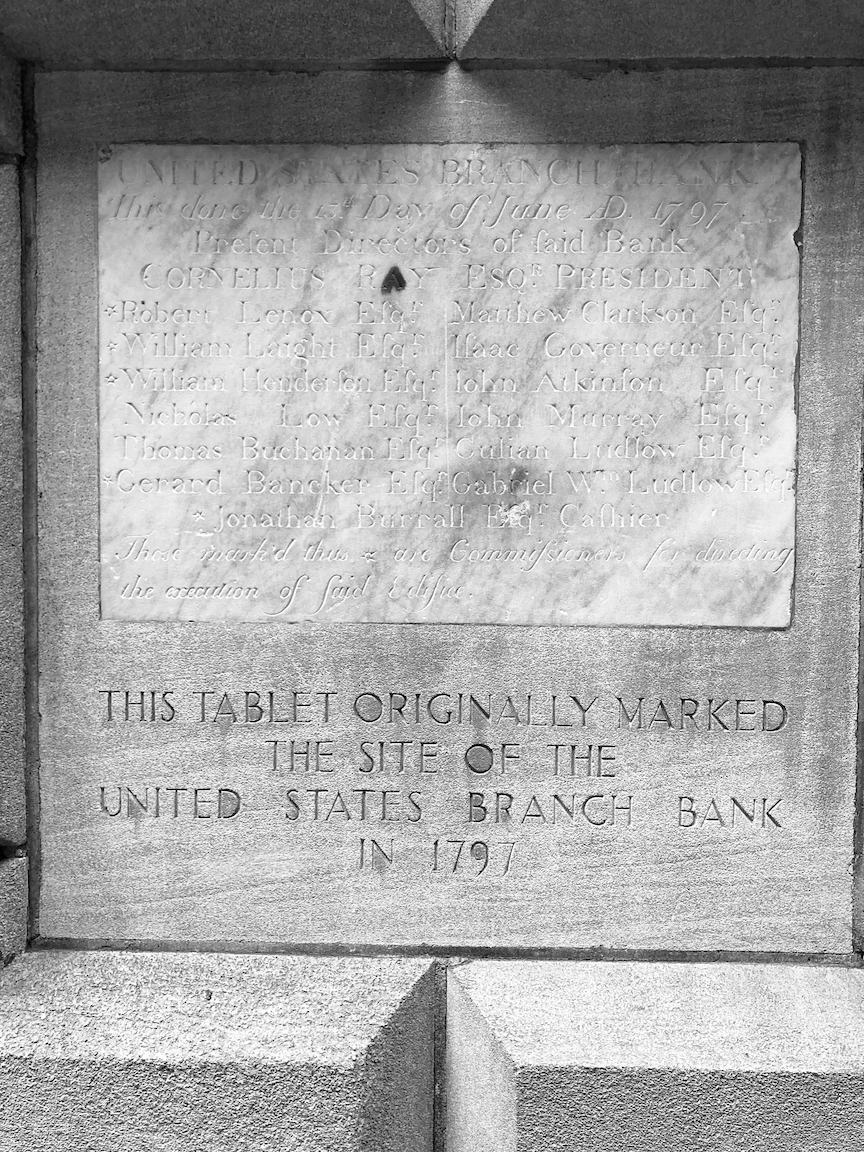
To your left on Wall Street is 40 Wall Street (1930), built as the headquarters of the Bank of the Manhattan Company, one of the predecessors of the present-day JPMorgan Chase and now called The Trump Building. This building was in a competition with the Chrysler Building to be the world’s tallest office building. After it was topped out the Chrysler Building’s distinctive spire was hoisted into place, giving it top honors. Just past 40 Wall Street is 48 Wall Street (1929), the former home of the Bank of New York, a corporate predecessor of the present-day BNY Mellon. On the facade is a tablet that marked the site of the United States Branch Bank in 1797. The Bank of the United States was established in 1791 to serve as a repository for federal funds and as the government’s fiscal agent. The Bank was based in Philadelphia with branches in eight cities.
From Federal Hall go uphill on Wall Street toward Broadway. On the left corner of Broadway is One Wall Street (1930), former home of the Irving Trust Company. If you can, get a look at the spectacular lobby. Across Broadway is Trinity Church. This, the third home of Trinity, was dedicated in 1846. Trinity received a land grant from Queen Anne in 1705 that covered Manhattan from modern-day Fulton to Christopher Streets and from Broadway to the Hudson River. Trinity has sold much of its granted property but retains a lot of it. Step inside the church and look around.
Trinity Church. Photograph courtesy bdcnetwork.com.
Continue south on Broadway: left from Wall Street, right from Trinity Church. Alongside Trinity churchyard there is a pair of original (1905) cast iron subway entrances.
Turning right on Rector Street, halfway down the block is a plaque marking the site of the first home of King’s College, founded in 1754, now Columbia University.
Farther down Broadway in the Charging Bull statue. Installed in 1989, it depicts a bull, the symbol of financial optimism and prosperity, leaning back on its haunches and with its head lowered as if ready to charge. It has been the occasional object of protests and vandalism, and has been likened by some to the Biblical golden calf. Children love to climb on it.
Photograph courtesy superiorwallpapers.com.
Just beyond is Bowling Green, New York City’s oldest park. Bowling Green was first designated as a park in 1733, when it was offered for rent at the cost of one peppercorn per year. Lessees John Chambers, Peter Bayard, and Peter Jay were responsible for improving the site with grass, trees, and a wood fence “for the Beauty & Ornament of the Said Street as well as for the Recreation & delight of the Inhabitants of this City.” A gilded lead statue of King George III was erected here in 1770, and the iron fence (now a New York City landmark) was installed in 1771. After the reading of the Declaration of Independence on July 9, 1776, a mob that included Alexander Hamilton (King’s College class of 1776) pulled down the statue and melted down much of it for musket balls. The king’s crown from the statue resides to this day in the Trustees’ Room at Columbia University’s Low Memorial Library.
Linger in the park. Think of all the history that is all around you. From here take the elevator or stairs down to the Bowling Green subway station.


