Flushing Meadows to Grand Army Plaza via Corona Avenue
START: The Unisphere, Flushing Meadows - Corona Park, Queens
FINISH: Grand Army Plaza, Brooklyn
DISTANCE: 10.7 miles (17.3 kilometers)
DIFFICULTY: Easy - moderate. A long but gentle uphill on Vanderbilt Avenue, and several places requiring caution, all noted in the text.
Turn sheet is at https://goo.gl/maps/qYa7CBMVFKv2fkBB7.
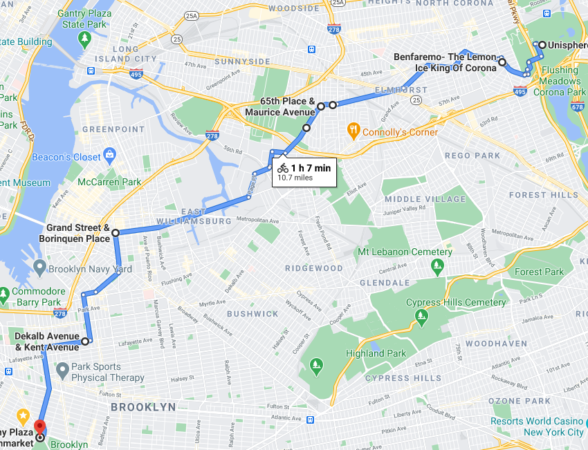
Map courtesy Google Maps.

Profile of this ride, courtesy Google Maps.
This is a shorter return route than the route via 34 Avenue but it is not without interest. Leave Flushing Meadows - Corona Park south of the Queens Museum, crossing over the Grand Central Parkway and winding through the park to Corona Avenue. Turn right on Corona Avenue and stick with it. At National Street bear left to stay on Corona Avenue, and do the same at 91 Street. Just past Broadway, bear right onto 51 Avenue. Just past there you’ll cross Queens Boulevard at a sharp angle, making for a long crossing. The middle part of the ride (Queens Boulevard to the Metropolitan Avenue Bridge) is industrial.
Watch for speed humps on Maurice Avenue as you pass the cemetery, and again on 58 Street. Coast over the 6-track railroad crossing; it’s a bit rough. Shortly afterward you’ll go over two bridges:
The Grand Street Bridge is narrow and has a steel grid deck, but it’s short.
The Metropolitan Avenue Bridge is also short but it has more traffic, traveling at higher speeds, than the Grand Street Bridge. Stay to the right and take care getting back onto Grand Street. If you’re not familiar with this crossing, continue to the first traffic signal (Vandervoort Avenue, by the filling station), turn left, then right onto Grand Street.
Stay on Grand Street to Union Avenue, turn left, then just before the elevated subway turn right onto Heyward Street. At Wallabout Street, turn right then make a quick left onto Franklin Avenue. From there, right onto De Kalb Avenue and left onto Vanderbilt Avenue to Grand Army Plaza.
This route has on-street bike lanes only on Grand Street west of the Metropolitan Avenue Bridge, and starting on Franklin Avenue to Grand Army Plaza. Stay alert; it’s a good and easy ride if you do.
Some points of interest along the way:
The Lemon Ice King of Corona, corner Corona Avenue and 52 Avenue. Old-school Italian ices. A longtime must-stop for me on the way back from Flushing Meadows.
Corona Avenue. This street traverses a nice cross-section of the many nationalities living in this area: Mexican, Italian, Colombia, Ecuadorean, Argentine, Indian, Chinese. Have a good look at the storefronts and other buildings along the way.
Dutch Reformed Church of Newtown, corner Corona Avenue and Broadway. The congregation dates to 1731 and the current church building opened in 1835. The churchyard likely dates to the founding of the congregation. From the Website Urban Archive: “Today the community, reflecting the multiculturalism that is present throughout Queens, the church now offers services in English and East Asian languages.”
Grand Street Bridge. This “Tinkertoy Bridge” was built primarily for streetcars and opened in 1903. It is a center swing bridge over Newtown Creek. Take care riding on its steel grid deck.
Metropolitan Avenue Bridge. This lift bridge over English Kills opened in 1933. Watch for traffic merging and diverging at speed.
47th Regiment Armory. This great pile dating from 1884, with battlements and a huge drill hall, occupies the entire block bounded by Heyward Street, Harrison Avenue, Marcy Avenue, and Lynch Street, was occupied by the U.S. Army and then the National Guard until 2011. It is in the Hasidic Jewish community in South Williamsburg.
88th Police Precinct, corner De Kalb and Classon Avenues. A small fortress for the local police precinct, built in 1889 and expanded in 1929.
Flushing Meadows to Grand Army Plaza via 34 Avenue
START: The Unisphere, Flushing Meadows - Corona Park, Queens
FINISH: Grand Army Plaza, Brooklyn
DISTANCE: 13.1 miles (21.1 kilometers).
DIFFICULTY: Easy with long and gentle climbs on 34 Avenue and Vanderbilt Avenue.
Turn sheet is at https://goo.gl/maps/9codK36QCjjFk7KXA

Map courtesy Google Maps.

Profile of this ride, courtesy Google Maps.
This is one of my two regular return routes from Flushing Meadows. A lot of this route is along bike lanes and bike paths, including the northern part of the Brooklyn Waterfront Greenway.
Start from the Unisphere past the USTA Billie Jean King National Tennis Center, north paralleling the Grand Central Parkway, underneath Roosevelt Avenue and the elevated no. 7 subway line, past the parking lot for Citi Field. The parking lot is where Shea Stadium once stood. Go left toward the elevated highway, then left again onto the bike path leading to 34 Avenue. This is a longtime bike route and since the pandemic much of it has been closed to cars as an Open Street. Watch this video. Don’t be too concerned about having to take your time along here.
Wind through Woodside and Sunnyside Gardens, an English-style garden community built in the 1920s. Continue along Skillman Avenue, right on Queens Boulevard over the rail yard, left on Jackson Avenue (be careful here!), left onto the Pulaski Bridge bikeway, then to Franklin Street/Kent Avenue (the Brooklyn Waterfront Greenway), past the Brooklyn Navy Yard and on to Grand Army Plaza.
Some points of interest along the way:
Sunnyside Gardens. Built in the 1920s as a garden community close to Manhattan, accessible by the then-new Flushing subway line (today’s no. 7 line). This leafy community of attached two-story brick houses has common back yards. You’ll get a good look riding along 39 Avenue and 48 Street.
P.S. 1, on Jackson Avenue. This was built in 1892 as Public School 1 in the then-independent municipality of Long Island City. It was absorbed into New York City, along with the rest of the western half of Queens County, in 1898. (The eastern half did not become part of the city and is today’s Nassau County.) P.S. 1 is now an outpost of the Museum of Modern Art.
Astral Apartments, Franklin Street at India Street. From Wikipedia: “The Astral was built in 1885–1886 as affordable housing for employees of Charles Pratt's Astral Oil Works. It is a block-long brick and terra cotta building in the Queen Anne style.” It certainly is grand. Charles Pratt made his fortune in kerosene and would found the Pratt Institute in Brooklyn, a school of art, architecture, and engineering.
Domino Park, River Street (west of Kent Avenue), north of the Williamsburg Bridge. This new riverfront park incorporates some parts of the Domino sugar refinery that long stood on the site. Ships would unload sugar cane directly to the refinery. This is a beautiful and very popular park. At its southern end is Grand Ferry Park, on the site of the former landing of the ferry from Grand Street in Brooklyn to Grand Street in Manhattan.
Naval Cemetery Landscape, Williamsburg Street West. The Brooklyn Greenway Initiative (BGI), of which I was Board Chair from 2013 - 2019, created and manages this space. It is on the site of the cemetery that was attached to the U.S. Naval Hospital, which was relocated to St. Albans, Queens during World War II. The remains in the cemetery - most of them, anyway - were reinterred elsewhere. Some remains are believed still to be there. With funding from the TKF Foundation and spearheaded by BGI co-founder Milton Puryear, this was created as a contemplative space to honor the people buried there and to provide a quiet, green space for the community. Stop and visit, and find out more at brooklyngreenway.org.
Brooklyn Navy Yard. The Naval Cemetery Landscape is at the eastern end of the former Brooklyn Navy Yard, which has become a thriving industrial park that is home to Steiner Studios, Kings County Distillery, Rooftop Reds, ship repair, and much else. There’s a fine, free visitor center with bike parking on Flushing Avenue near Carlton Avenue. For tours of the Navy Yard visit my friends at turnstiletours.com.
Flushing Meadows to Kissena Park and return
START/FINISH: The Unisphere, Flushing Meadows - Corona Park
DIFFICULTY: Easy to moderate. There’s one good hill from College Point Boulevard to Main Street. And make the left turn from Main Street to Dahlia Avenue with care.
This is a short (5.6 miles / 9.0 kilometers) add-on to a ride to Flushing Meadows, to delightful Kissena Park. This is part of a green belt that starts at Flushing Meadows - Corona Park and runs through to the Vanderbilt bike trail (which I’ll include in a future post) and Alley Pond Park. Kissena Lake is a real gem.
Go through Flushing Meadows - Corona Park past the elevated Van Wyck Expressway, and cross College Point Boulevard, going up the hill past Main Street. You’ll be on Booth Memorial Avenue, bordering Kissena Park, and turning left onto Kissena Boulevard, Right on Rose Avenue and an immediate right onto the park trail, which you can take to the lake. Take a break here and enjoy. Go north and west, exiting onto Oak Avenue. From there follow the turn sheet.
On the return trip, be careful on the one block of busy Main Street you’ll be on, making a left turn onto Dahlia Avenue. At College Point Boulevard turn left and then a quick right into the park; you’ll pass a soccer field on the left.
Turn sheet at https://goo.gl/maps/rBtqDdsc8sJTzxvt8
Some points of interest along the way:
Kissena Velodrome. Off Booth Memorial Avenue, east of Kissena Boulevard. Built as part of New York’s failed bid for the 1940 Olympics that never took place, it is New York City’s only velodrome. Going around those banked curves at speed is a thrill.
Kissena Lake. I happened upon this riding back toward Brooklyn some years ago. It’s a beautiful oasis right in the middle of a residential part of Queens.
Queens Botanical Garden, entrance on Crommelin Street.
USTA Billie Jean King National Tennis Center: Louis Armstrong Stadium (built for the 1964-1965 World’s Fair) and Arthur Ashe Stadium.

Map courtesy Google Maps

Tricycle! Tricycle!
I’ve known the creators of Turnstile Tours (http:/www.turnstiletours.com), Cindy and Andrew, for about a dozen years. They do walking tours all around the city, and since the pandemic they’ve done virtual tours in the city and elsewhere. I was introduced to Sandra, the force behind AdaptAbility, about a year and a half ago. AdaptAbility builds adaptive transportation for people with disabilities - first kids,now adults as well.
Cindy and Andrew wanted to do a segment about AdaptAbility, featuring Sandra and including an interview with me. We did it yesterday and it’s a blast. Most of the time is rightly spent with Sandra; the interview with me, in Prospect Park, starts at around 40:15. You can watch the video below.
Get in touch if you want to join me on a trike ride!
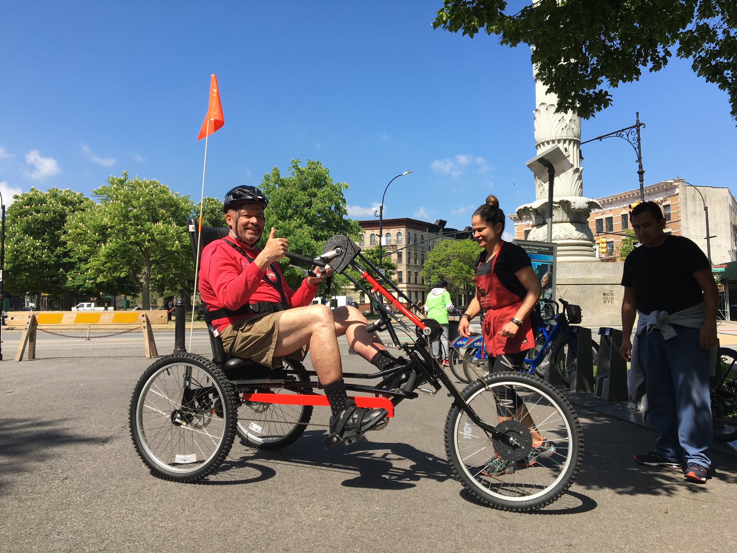
Day 1 on the tricycle, May 2019, with Michael and Sandra. Photograph by Nick Peterson.
Grand Army Plaza to Flushing Meadows
START: Grand Army Plaza, Brooklyn
FINISH: The Unisphere in Flushing Meadows - Corona Park, Queens
DIFFICULTY: Easy. No big hills. Watch for traffic approaching Fulton Street, making the left turn from Myrtle Avenue to Central Avenue, and between Station Plaza and Queens Boulevard in Forest Hills.
Flushing Meadows is one of my favorite destinations for a casual bike ride. It was the site of the 1939-1940 and 1964-1965 World’s Fairs. Only one structure from the 1939-1940 Fair remains, the Queens Museum (built as the New York City Pavilion and worth a visit). Several structures remain from the 1964-1965 Fair, including the Fair’s focal point and the end point of this ride, the stainless steel Unisphere. Today, Flushing Meadows - Corona Park is a vast playground for the richness and diversity of Queens.
The route follows bike lanes only on some portions but there isn’t much traffic except along 71 Avenue in Forest Hills. It goes through the neighborhoods of Prospect Heights, Crown Heights, Bedford-Stuyvesant, and Bushwick in Brooklyn; and Ridgewood, Glendale, and Forest Hills in Queens.
Look for a separate blog post for two different return routes.
Some points of interest along the way:
Grant Square, intersection of Bedford Avenue, Rogers Avenue, and Dean Street. Note the large equestrian statue of Gen. Ulysses S. Grant and, behind it, a grand late-19th Century structure in need of some tender loving care, the Union League Club.
Mount Lebanon Baptist Church, on Decatur Street as you turn off Lewis Avenue. I stopped in front of this church one day when I was riding out to Flushing Meadows with friends from Montreal. I had never stopped to look at this impressive church from the 1880s. That day, a member of the congregation happened to be in front and asked if we’d like a look inside. It is a beauty.
Myanmar Baptist Church, 78 Avenue at 79 Street. A humble building and a congregation for the growing Burmese community in Queens.
Station Plaza, Forest Hills. Named for the Long Island Rail Road station. Note the Tudor-style buildings surrounding the station, a focal point of this wealthy early 20th-century planned community. Ride carefully on those brick pavers!
McMansions in Forest Hills. Ugly. You’ll see a lot of them on 112 Street.
Flushing Meadow Lake. A pleasant place to stop just before the Unisphere.
The Unisphere. Built entirely of stainless steel and a gift from the United States Steel Corporation. The fountains surrounding the Unisphere are normally off except in summer, around the time of the U.S. Tennis Open.
Turn sheet for this ride is at https://goo.gl/maps/VrnHMdozxg8mfPLdA

The Unisphere. Photograph by Michael Cairl.

Map courtesy Google Maps.

The Narrows - Coney Island - Ocean Parkway
START/FINISH: Grand Army Plaza, Brooklyn.
DIFFICULTY: Easy. Only one significant hill, in Prospect Park near the end of the ride. You might well encounter cross winds along the Narrows and Gravesend Bay.
This is a ride I used to do early on a Sunday morning before breakfast. Take the West Drive through Prospect Park then take the route counter-clockwise. There isn’t too much traffic until Cropsey Avenue. Stop on the Bay Ridge Pier for a nice view of the harbor. Before the Verrazzano-Narrows Bridge opened in 1964, a ferry took passengers and cars from this point to Staten Island.
Enjoy a great ride along the water, past the bridge and past Calvert Vaux Park (on the right, near 25 Avenue). Watch for traffic along Cropsey and Neptune Avenues, especially where those two streets intersect, then take the Ocean Parkway bike path (opened in 1895!) to Prospect Park. On the left, just before the Belt Parkway, is Abraham Lincoln High School, with too many notable alumni to list. Look it up.
The turn sheet for this ride is at https://goo.gl/maps/kGi5hJABCP5tKuJr5; start at step 8.

This is a look at some favorite explorations I’ve done by bike, in and around New York City. Seeing the city from atop a bike is special; you’ll really see it differently than on foot and certainly differently than from a car or bus.
PLEASE! Wear a helmet, use hand signals, obey the rules of the road, and look out for pedestrians, motorists, and other cyclists.
I’ll include a detailed description for each ride, that you can use or modify for a turn sheet. Enjoy and let me know what you think!