City Hall Loop
WHERE: A loop around City Hall Park in Lower Manhattan.
START/FINISH: Fulton Transit Center: Fulton Street subway station (2, 3, 4, 5, A, C, J trains), fully accessible
DISTANCE: 1.1 miles (1.8 kilometers)
Photographs by Michael Cairl except as noted. Map courtesy footpathmap.com.
Map of this walk, starting and finishing at lower left.
Lower Manhattan is where New York began, with the settlement of New Amsterdam, founded by the Dutch West India Company in 1626. In 1664 Britain took over, the Dutch trading post became English, and it acquired a new name, New York. Until well into the 20th Century Lower Manhattan was the business center of the city - it is still called the Financial District - and it remains the location of many city, state, and federal government functions. Yet many older office buildings have “gone residential” or been converted to hotels or other uses. Prior to the COVID-19 pandemic, many large offices migrated to newer buildings with large floor areas. Arguably there was too much office space before the pandemic, and the future of office work is unsettled. Yet Lower Manhattan evolves.
Start at the Fulton Transit Center, at the southeast corner of Broadway and Fulton Street. This was built in the years following the attacks on September 11, 2001, to improve connections among, and bring accessibility to, the four subway stations there. The Fulton Transit Center is a qualified success; transferring from one station to another is certainly clearer than it was, and numerous elevators and escalators make the whole complex more easily navigable. It is also connected, by a passageway underneath Dey Street, to the World Trade Center transit hub (1, E, R subway lines and PATH trains to New Jersey). But the four subway stations, which opened in 1905 (4 and 5 trains), 1919 (2 and 3 trains), 1931 (J train), and 1933 (A and C trains), were never designed to connect easily with each other. The placement of the J train station in particular makes the whole complex still problematic. Nevertheless, it is much better than it was.
Exiting the Fulton Transit Center, cross Fulton Street and walk north on Broadway. On the left is St. Paul’s Chapel, built between 1764 and 1766 as an outpost of Trinity Church a few blocks south on Broadway. Its wooden steeple was buiilt betwen 1794 and 1796. It is the only extant pre-Revolutionary building in the original city of New York. Miraculously, St. Paul’s had only minor damage from the collapse of the World Trade Center towers, and was a gathering place for rescue workers. President George Washington worshipped here.
The steeple of St. Paul’s Chapel with the World Trade Center in the background, 1981.
Cross Ann Street and Park Row (going diagonally to the right), continuing to City Hall Park, then turn right. In pre-Revolutionary times the space occupied by City Hall Park, City Hall, and the area between City Hall Park and Chambers Street was known as the Commons. The AIA Guide to New York City, Fifth Edition (2010), notes “Buildings, seemingly for random purposes at random locations, occupied pieces of this turf from time to time.” The park itself was the site of the General Post Office from 1871 to 1938. The fountain in the park is a reproduction of the fountain that was moved to Crotona Park in the Bronx to make way for the Post Office. We will note the locations of other such random buildings along the way.
Park Row was not only the eastern boundary of the Commons, it was also the southern end of the Boston Post Road, which for most of its length is U.S. Route 1. At Spruce Street, cross Park Row to see the statue of Benjamin Franklin, noting his work as a printer and dating from 1872. The intersection of Park Row, Spruce Street, and Nassau Street is known as Printing House Square, and the east side of Park Row used to be known as Newspaper Row as severtal of the city’s newspapers had their offices and were printed there.
Cross Park Row back to the City Hall Park side and turn right. On the left you’ll see Steve Flanders Square, named for the reporter (1918 - 1983) from radio station WCBS who covered City Hall for decades. City Hall dates from 1812 and has been altered several times. When built it was near the northern edge of the city, and while the southern facade was clad in marble the northern facade was constructed of less costly material. Today, the facade is uniform (limestone) all the way around. The most ornate room is the Council chamber. The Mayor doesn’t always work from City Hall; Michael Bloomberg, when he was Mayor (2002 - 2013) worked from the Tweed Courthouse directly behind City Hall.
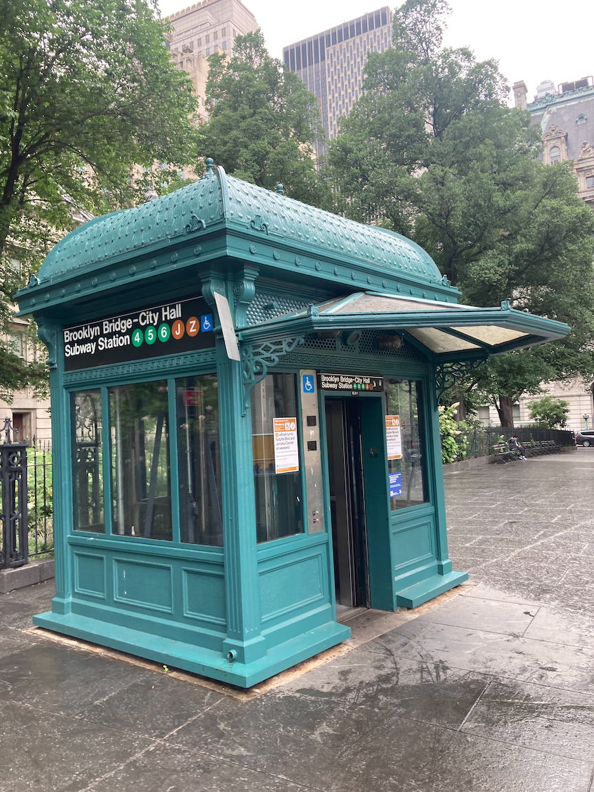
Continue past the entrances to the Brooklyn Bridge - City Hall subway station. Notice an ornate entrance to the elevator leading down to the subway station. This is a reproduction of the shelters, known as kiosks, over the stairways to the stations on the first subway, which opened in 1904.
Across Park Row is the Brooklyn Bridge. At one time the view of the bridge was obscured by a terminal for Brooklyn elevated trains. Immediately north of that terminal was the City Hall terminal of the Second and Third Avenue elevated railways. Both terminals were demolished in the 1950s. There has long been a lot of transportation at this location.
In the park on the right there is a stone marker noting some of the structures built in the Commons in the 18th century: the Almshouse for the poor, military barracks, the New Gaol (British spelling of “jail” with the same pronunciation) on the site of the marker, and another prison called the Bridewell, facing Broadway.
From Archaeology Archive:
The New Gaol, erected in 1759, was built in response to New York City’s growing crime problem. The three-story masonry building in the northeast of the Commons was originally intended to house convicted criminals, but served multiple functions throughout its history. The new building was soon used for debtors and prisoners-of-war during the French and Indian War. Its location next to the Almshouse and its growing use for debtors soon led to the appellation “the debtor’s prison.” A continuing rise in crime and the resultant overcrowding of the New Gaol led the city to begin construction of the Bridewell in 1773, where some felons were moved two years later. During the Revolutionary War, the Gaol was crowded with American prisoners. After the War, the building was returned to its earlier function of housing felons and debtors, the latter of whom paid for their own clothing, food, and fuel. The Gaol continued to house prisoners until 1824. It was slated for demolition, but was eventually refurbished and converted to a Hall of Records for the city in 1830. The building was torn down in 1903, at which time it was the oldest civic building in New York City.
The Hall of Records, formerly (without the classical portico) the New Gaol, demolished in 1903. In the foreground is the overpass to the Brooklyn Bridge terminal. In the right background is City Hall. In the left background is the General Post Office, demolished in 1938. Photo courtesy New York City Municipal Archives.
Constructed in 1775, the Bridewell was meant to be a debtor’s prison and workhouse. However, for the duration of their occupation during the Revolution the British used the building as a prison for American prisoners of war. During the War of 1812, the occupying British again used the Bridewell as a place to house prisoners of war. It was only after the War of 1812 that the Bridewell returned to its original purpose as a general city jail.
The most famous inmate at the New Gaol was William Duer, known as the first Wall Street villain and a key figure in the Panic of 1792. The Bridewell got its name from a jail of the same name in London.
To your right, across Centre Street, is the Municipal Building, which opened in 1914 and houses many city offices. It straddles Chambers Street, and through the archway one can see the headquarters of the New York Police Department, One Police Plaza (1973). Atop the colonnade in front of the Municipal Building is inscribed NEW AMSTERDAM MDCXXVI. then MANHATTAN, then NEW YORK MDCLXIV. Look up.
Cross Chambers Street. On your left is the Surrogate’s Court, which opened in 1907. In New York State the Surrogate’s Court is sometimes referred to as “widows and orphans court” and adjudicates disputes concerning estates. Cross Reade Street. To your right is Foley Square, around which are state and federal court houses on the east side, and the Federal Building and Court of International Trade on the west side.
Surrogate’s Court.
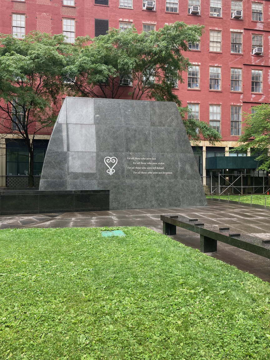
Turn left onto Duane Street. At the corner of Elk Street is the African Burial Ground National Monument. During the construction of the Ted Weiss Federal Building in the early 1990s, over 400 sets of human remains were discovered. This area had been a burial ground, just north of the old city limits, for over 20,000 “Negroes” in the 17th and 18th centuries, Read the interpretive signage. then walk through the monument. This is a moving memorial and tells a chapter of this city’s history that is not known enough.
Two views of the African Burial Ground National Monument. In the upper image, the inscription reads “To all those who were lost, For all those who were stolen, For all those who were left behind, For all those who were not forgotten”
Turn onto Elk Street and walk the two short blocks to Chambers Street, then turn right. The first building on the right is the former Emigrant Industrial Savings Bank (1908 - 1912), now an exhibition space called Hall des Lumieres. Across Chambers Street is the former New York County Courthouse, better known as the Tweed Courthouse (1861 - 1872). The construction “cost” was over $14 million, exorbitant for the time. The de facto mayor of New York, William Marcy (“Boss”) Tweed, who headed the New York County Democratic organization (Tammany Hall), pocketed some $10 million of that total. Today the building is used as municipal offices.
Continue walking toward Broadway. On the right is a white-painted building that was built as the A.T. Stewart Dry Goods Store (1845 - 1846), the first great department store. Stewart is perhaps better known for developing Garden City, Long Island in the 1870s. Stewart’s store was taken over by the New York Sun newspaper, which installed the ornate clock on the corner of the building that reads “The Sun It Shines for All.” The building is now occupied by the New York City Department of Buildings.
Cross Chambers Street onto the east (park) side of Broadway. In the park near Warren Street there is a set of foundation stones. These are what is left of the Bridewell, which stood on this site. In the sidewalk there is a plaque noting the location of the British army barracks.
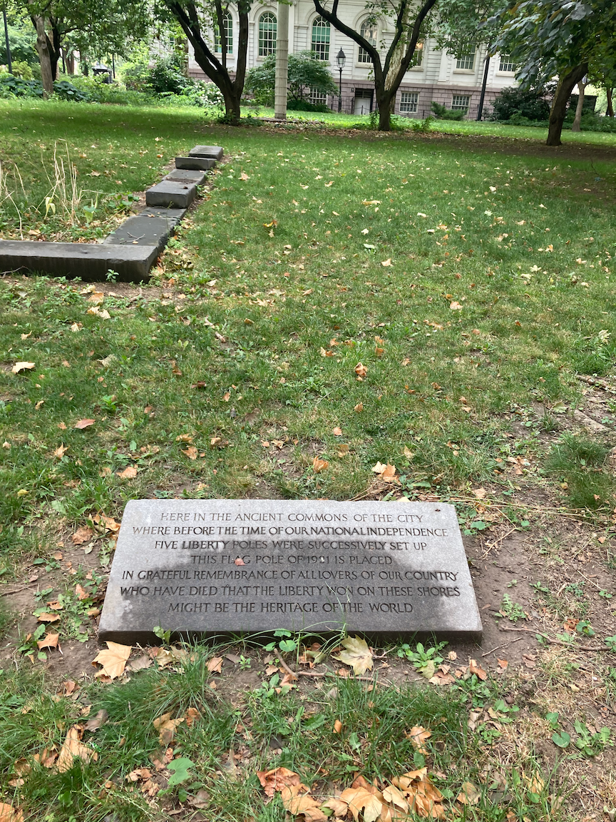
Continue walking and on the left is a plaque pointing to a flagpole erected to commemorate the five Liberty Poles built in the Commons during the Revolution, as a rebuke to the British occupiers.
Liberty Poles plaque, foundation stones of the Bridewell to the left.
Across Broadway at Park Place is the Woolworth Building (1913). When it was completed, and until the completion of 40 Wall Street and the Chrysler Building in 1930, it was the world’s tallest office building. It was the longtime headquarters of the now defunct F.W. Woolworth Company and was known as the “Cathedral of Commerce.” If you ever get the chance to take a guided tour of the lobby, do so.
Continue down the same side of Broadway to end at the Fulton Transit Center, or relax in City Hall Park, or take a moment for quiet contemplation in St. Paul’s Chapel.
This short walk packs in a lot of architectural and historical interest and begins a look at the exploitation of African-Americans, something to which we will return on future walks.


