Weeksville and Bedford-Stuyvesant (Brooklyn)
WHERE: Northeast Crown Heights, Stuyvesant Heights, and more
START: Crown Heights - Utica Avenue subway station (3 and 4 trains), fully accessible
FINISH: Herbert Von King Park, then B38 bus on DeKalb Avenue
DISTANCE: 3.3 miles (5.3 kilometers)
Photographs by Michael Cairl except as noted. Map courtesy footpathmap.com.

Map of this route, reading from bottom to top.
I didn’t have a particular theme in mind for this walk, just some places I wanted to see, specifically the Weeksville Heritage Center and a lot of knock-your-socks-off late 19th-century architecture. I saw all that, and more, on this warm but pleasant day.
The walk started at the busy subway station at Utica Avenue and Eastern Parkway, connecting to several bus lines and the hub of the Utica Avenue commercial corridor. Several peddlers set up shop by the subway entrance. Walking east on Eastern Parkway, it didn’t take long to get away from the commerce. Between Rochester Avenue and Buffalo Avenue, a couple of houses with front porches caught my eye.

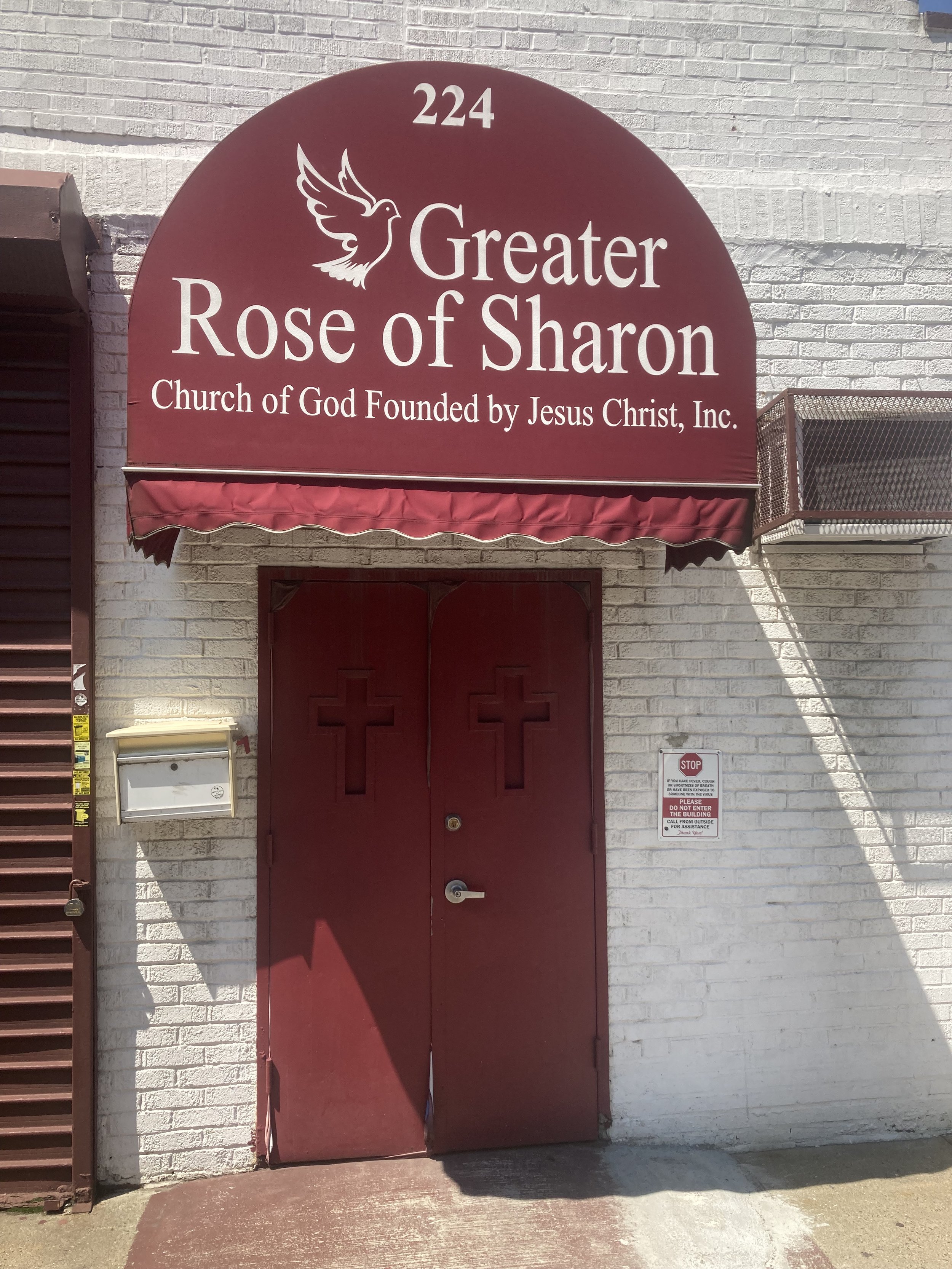
I turned left onto Buffalo Avenue and walked north. Brooklyn has long been called the Borough of Churches (before 1898 it was the City of Churches). This walk took in many grand churches but on one block of Buffalo Avenue I counted four churches housed in humbler dwellings. This was one.
Between St. Marks Avenue and Bergen Street is the Weeksville Heritage Center. Weeksville was a community of people freed from slavery after slavery was abolished in New York in 1827. From their website:
Weeksville Heritage Center is an historic site and cultural center in Central Brooklyn that uses education, arts and a social justice lens to preserve, document and inspire engagement with the history of Weeksville, one of the largest free Black communities in pre-Civil War America, and the Historic Hunterfly Road Houses.
A handsome, understated modern building on Buffalo Avenue is the entrance to Weeksville. The grounds outside the building have sculptures, and a path follows the route of old Hunterfly Road. The old road was obliterated by the street grid in this part of Brooklyn. The Hunterfly Road houses were built around 1830. Weeksville became a thriving community that grew larger as African-Americans fled Manhattan during and after the draft riots of 1863. The AIA Guide to New York City, Fifth Edition, describes the houses thus:
Four simple wood houses occupied by James Weeks and friends (free black men) between 1830 and 1870. The architecture, in painted clapboard, is that of the 19th-century common man. It is the City’s oldest black residential landmark.


At the corner of Rochester Avenue and Pacific Street, Calvary Fellowship African Methodist Episcopal Church caught my eye. It’s small but commanding and offers a weekly soup kitchen and other community services.

To go from Crown Heights to Bedford-Stuyvesant one has to cross Atlantic Avenue. For most of its length, extending into Queens, it is wide, congested, and ugly. For most of its length the Long Island Rail Road runs beneath it or above it. On this walk I passed underneath it, continuing north on Rochester Avenue to Fulton Street, where I turned left, continuing to Stuyvesant Avenue, where I tuned right.
Brooklyn has several street grids. Crown Heights, both north and south of Eastern Parkway, has one. Bedford-Stuyvesant has another, slightly offset from the Crown Heights grid and extending to the west into Clinton Hill and Fort Greene. A number of east-west streets merge with Fulton Street at acute angles, as far west as Downtown Brooklyn. These streets are named for generals, admirals, and presidents, with two exceptions: Hancock Street and Lexington Avenue, about which a bit more later. The intersecting avenues were named for former governors of New York; some of those streets have been renamed.
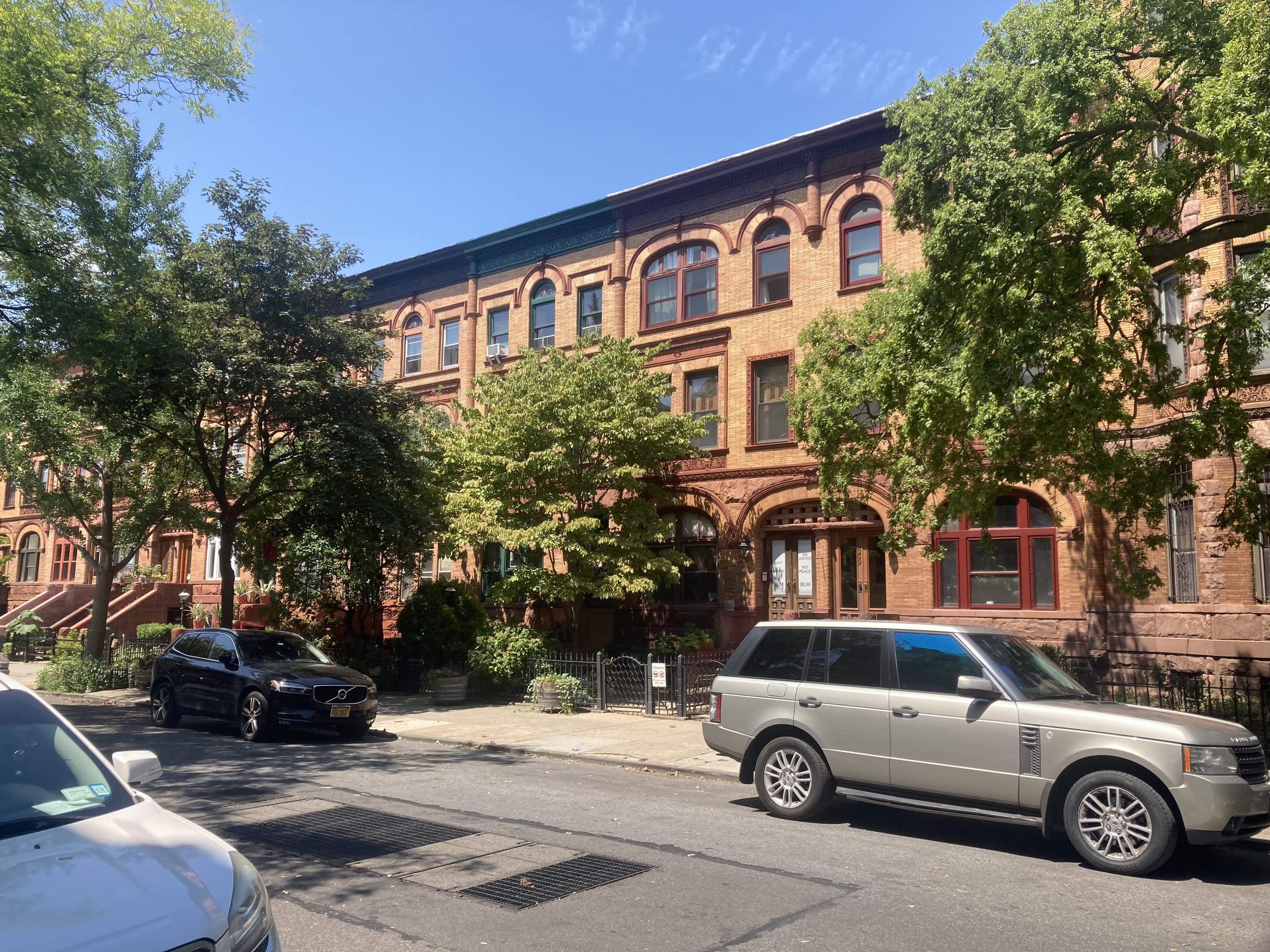
Turning onto Stuyvesant Avenue, one sees beautiful houses on tree-lined streets. Again from The AIA Guide to New York City, Fifth Edition:
… where Bedford-Stuyvesant has distinguished architecture, it is very good. Its façades of brownstones and brickfronts create a magnificent townscape as good - and sometimes better - than many fashionable areas of Brooklyn and Manhattan. Parts of Chauncey, Decatur, MacDonough, and Macon Streets, and the southern end of Stuyvesant Avenue, are superb. Hancock Street, between Nostrand and Tompkins Avenues, was considered a showplace in its time (late 1880s) and has been lovingly restored in recent years.


Stuyvesant Avenue, north of Chauncey Street.
Two blocks on, I turned left onto Decatur Street. This was a part of my bike route from where I live in Brooklyn to Flushing Meadow - Corona Park in Queens, and this part of the street is full of beautiful late 19th-century houses. Immediately I saw some grand houses I never quite appreciated while biking along here.
At the corner of Decatur Street and Lewis Avenue is the stunning Mount Lebanon Baptist Church. Years ago, on a bike ride with friends, we stopped to look and were invited inside by the sexton to look at the sanctuary. I could do a whole walk devoted to the churches of Bedford-Stuyvesant and another of the churches of Crown Heights. Perhaps I will.

Sanctuary of Mount Lebanon Baptist Church. Image courtesy of the church.
I turned right onto Lewis Avenue, walking past Peaches Restaurant (I have to go there sometime), then left onto the next street of beautiful old homes, MacDonough Street. At the corner of MacDonough Street and Throop Avenue is yet another grand church, Our Lady of Victory (Roman Catholic), dedicated in 1895. The façade is Manhattan schist, which darkens when exposed to air (see also the original quad at City College in Harlem), with limestone encasements.

I then turned right onto Throop (pronounced “troop”) Avenue and then left onto Macon Street. Directly across Throop Avenue is Newman Memorial United Methodist Church. African-Americans founded the Newman Memorial United Methodist Church as a mission church in the Old Embury Church at Herkimer Street. The congregation moved into this building (dedicated in 1912 as the Throop Avenue Presbyterian Church) in 1945.

I walked west on Macon Street to Marcy Avenue and turned right. Just east of Marcy Avenue on Hancock Street is the former John C. Kelley House, built in the 1880s. Again from The AIA Guide to New York City, Fifth Edition:
A formal freestanding neo-Renaissance town house (in Rome it would have been a palazzo, in Paris a hôtel particulier) on a triple-width site (81 feet), built for Kelley, an Irish immigrant who made his fortune in water meters. Legend claims that the brownstone was selected piece by piece to guarantee quality. Lovingly restored as a bed and breakfast.

The former John C. Kelley House.
The houses immediately to the west of the John C. Kelley House are impressive too.

Fronting on Marcy Avenue between Putnam Avenue and Madison Street is the former Boys’ High School (1892). It and the nearby former Girls’ High School on Nostrand Avenue (1885) were probably the crown jewels of the City of Brooklyn’s public school system. In those days one went to school at a place that looked important.
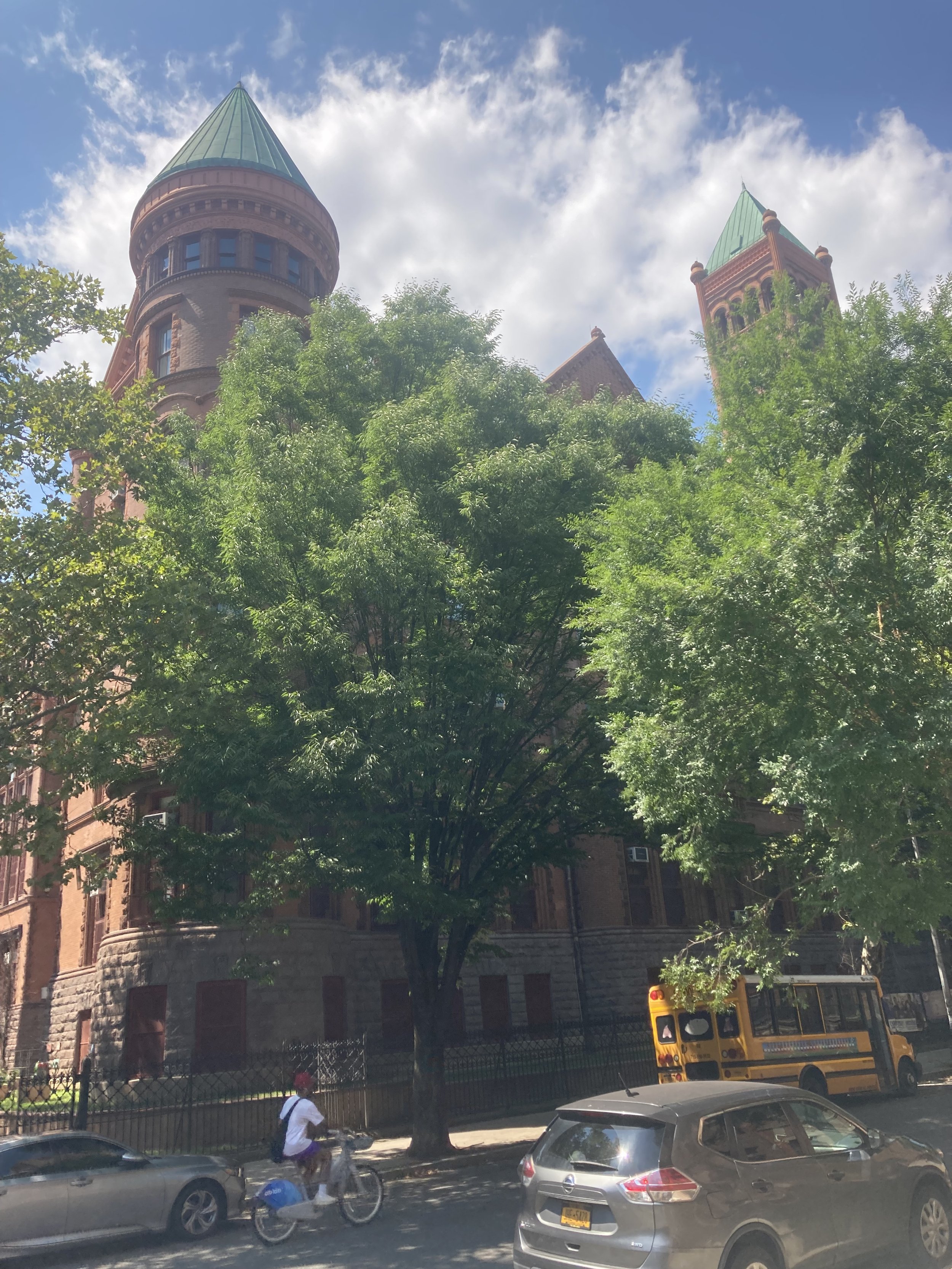
Former Boys’ High School.
Continuing north, I passed Lexington Avenue. This street might be charitably described as nondescript, perhaps a legacy of Brooklyn’s first elevated transit line running above it from 1885 to 1950.

Lexington Avenue elevated, 1950. Source: New York Public Library Digital Collections.
At Greene Avenue I came to Herbert Von King Park. This was not my first time there. The park was bustling with activity: people picinicking, playing with Frisbees, listening to music, or just sitting and relaxing. Black, white, old, young, gay, straight, they all enjoyed Bedford-Stuyvesant’s town square. From The NYC Parks website:
Acquired in 1857 by condemnation, this park was one of the first established by the City of Brooklyn. It was originally named for Daniel D. Tompkins, an abolitionist who served four terms as governor of New York (1807-17) and two terms as vice president of the United States under James Monroe (1817-25). It was not until 1871, however, that the plan for the park was submitted by Calvert Vaux and Frederick Law Olmsted, the designers of Prospect and Central Parks. Like most small parks of the time, Tompkins Park was planned as a public square used for ceremonies and military reviews. The designers provided for little more than border plantings of flowers and shrubs, claiming that trees and winding walks would result in the park being used, “for clandestine purposes by people of bad character.”
Historical additions to the park reflect changing uses of the site. Space was cleared in 1915 to accommodate the large crowds who turned out for concerts performed by regimental bands. A playground was built in 1927, and a public library that dates to 1915 was housed in the shelter building until it burned down in 1969. The group Tompkins Park Recreation and Cultural Association formed in the same year and mobilized to improve park facilities. Their efforts led to the 1973 opening of a new recreation center which houses the amphitheater, senior citizen and teen center, and an auditorium named after famed 20th century African American composer and musician of ragtime and jazz music, Eubie Blake. In the auditorium, a mural by artist Akwesi M. Asante depicts 50 African American icons, including Fredrick Douglass, Mayor David Dinkins, and the Jackson Five.
In 2011, the amphitheater was named in honor of Almira Kennedy Coursey (1914-1996), a lifelong educator and local resident who promoted the park’s transformation from a passive town square into a bustling center of activity in the heart of the Bedford-Stuyvesant neighborhood.
This park is named for Herbert Von King (1912-1985). King was called the “Mayor of Bedford-Stuyvesant,” and was an active community leader for over 50 years.
I cut diagonally across the park, exiting at Tompkins and Lafayette Avenues, then continuing to the end of the walk at Tompkins and DeKalb Avenues. Near the corner is Mount Pisgah Baptist Church, formerly St. Ambrose Roman Catholic Church (1907). This church was designed in an Italianate style with a façade copied from the Church of St. Prudentiana in Rome. The interior features a ceiling that reproduces that in the Cathedral of Pisa, with side decorations copied after those in the Cathedral of Ravenna.


Two views of Mount Pisgah Baptist Church.
There was so much to see on this walk, and so much that I missed. There were many block parties taking place on this fine day. Weeksville Heritage Center is definitely worth return visits, and I’m sure future walks will overlap this one. There was a great spirit in my city. And, last but not least, the whole walk was accessible.